
St. Albert’s history reflects a unique blend of geological and cultural influences. From ancient ice sheets shaping the land to European settlement and the rise of trading posts, the area evolved significantly. Once a vibrant community with rich resources for First Nations, it has transformed into a rapidly growing suburb, risking its fertile farmland to urbanization.

Please note that there are three ways to enjoy St. Albert. A walking tour is 10 KM long with a stop for Italian coffee about the 6 KM mark. A 22 KM cycling trip is possible but with the inconvenience of getting on/off your bike lots. A third way is to walk Stops 1 to 11 and then bike the remainder. For either of the last two options, wait until the end of the ride and enjoy coffee in downtown St. Albert.
- Fact Facts
- A Cross Section of Western Canadian History
- The Big Ice Cube
- Mixed Forest
- Trading Posts and the Push South
- Let’s Move Here!
- A Big Lake Nearby
- French and Catholic Influence
- Land Grants and Townships
- A (River) Lot to Talk About
- Training the Focus on Edmonton and Strathcona
- Growth is a Mixed Blessing
- St. Albert Walking Tour Details
- St. Albert Cycling Tour Details
- Notes and Reference
- Further Reading
Canada differs from the United States in the direction of European contact. For the US, contact was a relentless push west from the Atlantic to the Pacific. The same is true of Canada – but only after the railroads. Before that, the push was from the North to the South via trading posts.
Fact Facts
- EASY-PEASY
- Worth Visiting
- Washrooms.
- Kid Focused
A Cross Section of Western Canadian History
St. Albert was distant enough from Hudson Bay and Montreal to mean that when trading companies arrived, they already were well oiled-machines. However, long before the first Voyageur canoe showed up on the Sturgeon River, this area had already been changed through ancient seas, and climate. In this respect, St. Albert is a unique cross section of Western Canadian History. It is a story of people in transit, settling, being displaced, and settling again [1].
The Big Ice Cube
The modern (in geological terms) St. Albert story starts with the mothers of all ice cubes, the Cordilleran and Laurentide ice sheets. At the height of ice age, these two sheets touched and then began to retreat, Cordilleran back into the Rocky Mountains and the Laurentide up towards Baffin Island. The nature of this retreat is important because in between these two sheets was an ice-free corridor. According to the Clovis Theory, at least a portion of the first humans (and other critters) came through this corridor [2].

The retreating glaciers left behind a rich mix of silt and clay which would create exceptional farmland and something we will return to in a few thousand years – but first, the thick forest.
Mixed Forest
Southern Alberta is the Prairie and Northern Alberta is the Boreal Forest and in between is the Aspen Parkland. The North Saskatchewan River valley is roughly a transition between these last two. Bison and other herbivores used this transition zone to feed and live. Where there are Bison, the First Nations would soon follow.
This mixed forest provided greater resources for the Cree peoples who lived here versus the semi-arid prairie to the South, home to the Blackfoot. Without a handy embankment to drive the bison off similar to Head Smashed in Buffalo Jump. This diversity of game was critical. Now let’s fast forward to the 18th century and the trading companies.

Trading Posts and the Push South
Edmonton was strategically located between the Blackfoot and Cree First Nations. One of the intentions was to cut out the Cree who acted as the middlemen [3] for this trade.
While Fort Edmonton was relatively long lived, other trading posts winked in and out of existence much faster. Fort Saskatchewan, at the confluence of the Sturgeon and North Saskatchewan, still bears the HBC name. St. Albert briefly had a trading post; it was located about where the grain elevators now stand, but lasted only a few years.
Let’s Move Here!
As Europeans settled in the area, they ‘took’ native wives and became the Metis. Many of them French, they initially settled in and around Lac St. Anne, about 50 KM to the west. The problem with this area is that it lost the glacier lottery.
While St. Albert and the Edmonton area was blessed with clay and silt; moraines and rocks better describe the area around Lac St. Anne. While visiting his small flock on the Sturgeon River with Father Lacombe, Bishop Tache noted the much richer soil. He declared a new community to be established in in the area the Cree knew as Mista-sakahikun. [4]
A Big Lake Nearby
Central to this new community was the Sturgeon River. Unlike other Alberta rivers, the Sturgeon does not have its source in the mountains. Its 260 KM course starts near Isle Lake and meanders through Parkland towards St. Albert and eventually empties into the North Saskatchewan River near Fort Saskatchewan [8].
The Sturgeon and two creeks (ATIM and Carrot) provide the inflow for Big Lake. The name is an English translation of the Cree’s moniker “Mistihay Sakigan”. Big Lake makes up the majority of the Lois Hole Centennial Provincial Park. The lake itself is an import bird area and supports numerous critters along its shore including moose, coyotes, porcupines, and various rodents. A paddlewheel boat, the Ste. Thèrésa, took passengers to the lake from St. Albert, prior to the outbreak of WWI [9].
Although covering a larger surface area, the lake is shallow with a maximum depth of less than 4 M [10]. During late summer, it is not uncommon for the lake to shrink considerably from its Spring high water mark. A viewing platform at the terminus of the lake was re-built by the Big Lake Environmental Support Society in 2020.
French and Catholic Influence
As Alberta’s oldest non-fortified community, the area had a different start from most communities. Preceding Canadian confederation by six years, it had a strong French and Catholic flavour.
For many years, St. Albert was the center of Catholic activity not only in the area but in a large area including what is now the provinces of Alberta, Saskatchewan and the Northwest Territories. In 1871, Rev. Vital Grandin was appointed the first Bishop of the newly created See of St. Albert. The Bishop, his nine Oblate priests and a few brothers ministered to about 12,000 aboriginal peoples, 5,000 Métis and a few hundred European Immigrants [5].
Land Grants and Townships
As the bison waned and the First Nations and the Metis began to settle, land ownership began to be staked out. The Ontario system of surveying uses a six mile square ‘township’ which were then further divided into 36, one-square mile, sections of land. Each section is then broken into progressively smaller parcels. This is where the terms ‘full section’ (one square mile or 640 acres) or ‘quarter section’ (40 acres) comes from [9].
The township system can be seen today when flying over Western Canada. Tidy little squares of land were originally homesteaded and then later amalgamated into larger and larger farms. This ability to distribute land was the one asset the Canadian Government had in abundance and was how it could entice capital to construct railways and the like.
A (River) Lot to Talk About
The tidy townships did not always square the reality on the ground. Before the railway, a canoe was the most likely way to travel and therefore river frontage was of paramount importance – thus the river lot system.
This system is seen in Quebec along the major water ways, was how Manitoba was initially settled, and was preferred by the Catholic church enabled settlement. In addition to access to water, it also meant that neighbours were closer to each other.
The River Lot system is more than a historical curiosity, it was also the cause of the Riel Rebellions (extreme over simplification here) which continues to shape the Canadian cultural identity to this day.
The river lot system itself was doomed because of changing technology. For a while, paddle wheelers made river transport more efficient. But in a few decades, railways would prove that the Township system made the most sense to move goods to and from farms. Straight as an arrow Township lent themselves to roads and spur railway lines.
Training the Focus on Edmonton and Strathcona
While St. Albert was on the main travel routes to the rich trapping areas, the coming of the railway changed that. The train arrived in Strathcona in 1891, via the Calgary and Edmonton Railway (the CPR arrived in Calgary a decade earlier) [6]. This accelerated a move away from St. Albert to Edmonton. The North Saskatchewan River also provided better water access. St. Albert became a sleepy farming community with a population less than 1,000 until the early 1950’s [6].
Growth is a Mixed Blessing
In the late 1950’s city council actively promoted St. Albert as a bedroom community for Edmonton. Fast forward seventy-five+ years and its population increased from 1,100 to ~75,000.
While I appreciate this growth as I have a nice home to live in, the reality is that St. Alberta (and metro-Edmonton) is sitting on some of the best farmland in Alberta – which is being slowly (or not so slowly) lost to urban expansion. While pondering this fate, let’s take a 10km walk through St. Albert, a 22 KM bike ride, and grab a coffee.
St. Albert Walking Tour Details
The walking or cycling routes are both stand alone tours but are best done in combination. If combined, walk items 1 to 11 first and then ride the remainder.
Any maps and map views are for general information only. Do not rely on them for navigation or to determine legal boundaries.
1. Starting at the East Side of St. Albert Place (5 St Anne St, St. Albert, AB T8N 3Z9).
- Cross St. Anne Street and walk across the parking lot to Founders Court.
- The Big Ice Cube can be referenced either in front of the St. Albert Place or inside if weather is cooler.
- As of writing, St. Albert Place is open from 7am every day except statutory holidays. Water and washrooms are available inside.
2. Founders Court, west of Perron Street.
- The buildings of Founders Court a good discussion point for the ice-free corridor.
- A statue of St. Albert used to stand in this courtyard but was stolen in March 2023.
3. Cross to the East Side of Perron Street.
- Butt Hinge is both functional and whimsical and was created by Garry Jones in 1996.
- In 1997, it may have saved the lives of pedestrians as a motorist collapsed at the wheel and the massive sculpture stopped the vehicle.
- Location: 15 Perron Street, Courtyard
- Read More: Butt Hinge (1996).
4. Cross Perron Street: Butt Hinge.
- Butt Hinge is both functional and whimsical and was created by Garry Jones in 1996.
- In 1997, it may have saved the lives of pedestrians as a motorist collapsed at the wheel and the massive sculpture stopped the vehicle.
- Location: 15 Perron Street, Courtyard
5. Head south (left) along Perron Street
- Head south (left) along Perron Street towards the Clock Tower.
6. Clock Tower
- At the Clock Tower, note the calibration plaques and an information board for the Buffalo Hunt.
- The Clock Tower was built in 1995 as an engineering research project on how newly fired bricks cool.
- It was built with volunteer labour and has played a part in at least two research projects.
- A leaning tower was originally proposed.
- Read More: Perron Street Clock Tower | T8N.
7. Buffalo Hunt Statue.
- Cross the Sir Winston Churchill to the Southeast park and Buffalo Hunt Statue.
- Read More: New statue looks over downtown and historic past.
- Created by Don and Shirley Begg of Cochrane in 2011, the statue weights 800 lbs.
- This spot is a good location to discuss Mixed Forrest.
8. Time is a River
- Time is a River was developed as a lasting monument to pay tribute to the civic involvement.
- The project was installed in July 2011, and consists of five carved basalt standing stones.
- Location: 55 Sir Winston Churchill Avenue.
9. St. Thomas Street Artwork
- Created by Karen Ho Fatt, Blooms Bench (2001) is both a bench as well as an aesthetically pleasing taste of nature situated right in the heart of St. Albert’s Perron district.
- Wenden Way (1995), created by Ken Macklin, it is meant to explore the organic forms found in nature.
- Threshold (1999) represents a fifteen-foot-tall peregrine falcon with one missing wing symbolizes the persistence of a species: created by Robert Spaith.
10. Cross St. Anne Street
- Note the Court House to the left and the Arden Theatre to the right.
- In front of the St. Albert Place is the sculpture Hide & Seek (1994).
11. Walk Through St. Albert Place.
- Note the Stain Glass Windows above the North doors.
12. Art Work Behind (North) of St. Place.
- Directly behind St. Albert Place are a series of statues with a First Nations theme: Mother Earth Circling Buffalo (2006), Mother Bear Prays for Earth Healing (2007), and Buffalo Mountain (2010).
13. Children’s Bridge.
- Turn Left along the Red Willow Trail and Proceed to the Children’s Bridge.
- A grieving father originally asked that the bridge be named for his deceased daughter, killed by a drunk driver.
- Instead, it was named for all Children and in honour of the UN Year of the Child.
14. Healing Garden / Kâkesimokamik and ACT/UCT Celebration Gardens.
- Turn Right and pass the Healing Garden / Kâkesimokamik
- Continue and pass the ACT/UCT Celebration Garden.
15. Chapel of the Immaculate Conception and the Little White School.
- Turn Left before Perron Street.
- Pass by the Chapel of the Immaculate Conception
- Continue up the pathway towards the Little White School.
16. St. Albert Parish / Catholic Church.
- At the top of the escarpment, cross St. Vital Street.
- Head towards the St. Albert Parish / Catholic Church.
17. Mary’s Grotto and the St. Albert Roman Catholic Cemetery.
- Walk behind the church is Mary’s Grotto and the St. Albert Roman Catholic Cemetery.
18. McKenney Avenue, descend the hill.
- Continue North to McKenney Avenue and turn right to descend the hill.
19. Visit Michif Cultural Connections house
- Turn Right at Muir Drive, working your way through community of Mission.
- Visit Michif Cultural Connections house at the corner of Mission and Madonna.
20. Pass under St. Albert Road bridge.
- Continue East along Mission Avenue connecting to the Red Willow Trail System, pass under St. Albert Road bridge.
21. West along Boudreau Road.
- Continue on the Red Willow Trail System, heading East (down river) until reaching Boudreau Road.
- Go under the bridge and then turn Left to walk West along Boudreau Road.
22. Shops at Boudreau.
At Bellerose Drive, visit one of the businesses at the Shops at Boudreau.
23. Walk along the Sturgeon River via the Red Willow Trail System.
- After a cup of coffee and a treat, cross Boudreau Road and proceed South (away from Bellerose).
- Cross the Sturgeon River and exit and join the Red Willow Trail System.
24. Benoit Bridge and the 1888 NWMP Building.
- Proceed South/West along the trails (walking upstream). Along the Trail note the Benoit Bridge and the 1888 NWMP Building.
25. Pass the St Albert Cenotaph on St. Anne. Street.
- Cross Under the Perron Street Bridge and then Walk along Perron Street, turning Right at St. Anne Street noting the St Albert Cenotaph en route.
26. Finish the Walk in Front of St. Albert Place.
- Hopefully you enjoyed your walk and learned a wee bit, be sure to leave a comment or like!
St. Albert Cycling Tour Details
The following pertain to the cycling tour. Bikes can be locked up at St. Albert Place (or left in the vehicle) while walking the first part of the tour. The second part is then done on bike and covers additional stops and vistas not seen from the walking tour.
A. Starting at the East (Front) Side of St. Albert Place (5 St Anne St, St. Albert, AB T8N 3Z9).
- Walk your bike through St. Albert Place towards the river and note the Stain Glass Windows above the North Doors.
- Before riding, enjoy the sculptures behind the building (see item #12 above).
- Ride West (left) along the trail keeping the river on your right.
- Do not cross the Childrens Bridge (yet) but instead, turn left and head toward the Train Trestle.
- Keeping the river on your right, cross under the Ray Gibbons Bridge and continue toward the BLESS Viewing platform.
B. BLESS Viewing Platform
- The current viewing platform was rebuilt in 2020 by the Big Lake Environmental Support Society (BLESS).
- Since the early 1990’s, BLESS has been instrumental in ensuring this critical birding area has been protected and available for sustainable recreation.
- Head east along the gravel track towards Ray Gibbons Drive.
C. Lois Hole Centennial Provincial Park
- Turn Right along the paved path that parallels Ray Gibbon Drive.
- (Alternatively, turn right and cut through the parking lot of the Park, washrooms are available).
- (Alternatively, WALK bikes along the board walk to the parking lot).
- Cross Ray Gibbons at leClair Way.
- Established in 2005, the park is mostly made up of Big Lake (see notes above).
- Ducks Unlimited Canada constructed interpretive boardwalks on the ecological significance of the John E. Poole Wetland along the east shore of Big Lake (no bikes on the boardwalk).
D. Enjoy Center
- Ride North along Ray Gibbon Drive passing the Enjoy Center on the right.
- Turn right (East) on the trail North of the Enjoy Center and connecting to Levasseur Road.
- (Alternatively, ride along leClair and turn left on Riel Dr. to visit the Enjoy Center, washrooms are available).
- Formerly the Holes Enjoy Center, the facility was sold in 2019 after being openned by the Holes family in 2011.
- Previously, the Holes Greenhouses were located on the Sturgeon River and were openned in 1958 (just in time for the housing boom).
- This location was purchased and is now the site of an upscale shopping district and apartment complex that includes the Italian grocery store/deli Mercato.
E. Grandin Pond
- Continue on Levasseur Rd., turning left and following the sidewalk along Gervais to the Grandin Duck Pond Park.
- (Alternatively, turn left on Grandin Rd. to bypass the park).
- The St. Albert Drive In was located directly south of the pond (then known as the Grandin Slough) and was in operation from 1953 to 1990.
- Ride through the park and speed down Grandin Road.
- Crossing Sir Winston Churchill Avenue, follow St. Anne St. through the round about back towards St. Albert Place.
- In the round about is the public art piece ‘Migrations’. Installed in 2018 for a cost of $240,000, they look like sheaves of wheat from a distance but represent migrating Canada Geese on the stalks [11].
F. Re-join Walking Tour and a 2025 Trail Detour
- Follow the Walking Tour Route and note Walking Tour highlights #13 to 21.
- Cross the Sturgeon River to and then go under Boudreau Road keeping the river on your left.
- 2025 Construction Note: Red Willow Trail has a detour between the Blais bridge to Sturgeon Road. A temporary rubber sidewalk has been laid down, use with extreme caution noting the sharp shoulders. The detour is expected until the Fall of 2025, further details: https://stalbert.ca/dev/construction/utility/city/outfall-structure-improvements/.
G. St. Albert Botanical Gardens
- The 5-acre St. Albert Botanical Gardens were established in 1992 and show cases the plants that can thrive in the local climate [12].
- Entirely run by volunteers, the gardens host numerous wedding photo sessions throughout the year.
- The garden is free to enter but donations are welcome.
H. Kingswood Park and Riverlot 56.
- Continue along the trail (or the detour) to the terminus of the Trail System at Kingswood Park.
- Washrooms are available in the warm up shelter.
- Riverlot 56 adjoins the park to the North.
- It was privately owned until 1920 the Federal government purchased it to build the Edmonton Indian Residential School on the far east end on the site of what is now Poundmaker’s Lodge.
- The land was sold to the province in 1965 and was to be the site of the now Athabasca University (which moved to Athabasca in 1971).
- Used informally as recreation area since the early ’70’s, a society was formed from a coalition of organizations which allowed the site to be designated a Natural Area.
- The forest cover is likely original making this a glimpse into what the early settlers faced when clearing their own river lots.
I. Return to St. Albert Place
- This is the end of the cycling tour, return to St. Albert place via the South side of Red Willow Trail (keeping the river on your right).
- There are historical markers and vistas on this return journey so be sure to stop and read them.
- At the Benoit Bridge, follow the map route carefully, it is easy to climb up to Sturgeon road rather than staying in the river valley.
Area Details
- Name/Owner: Municipal Trails and Art Work.
- Is it Worth It and Why Go Here?: Overall (5 out of 5) An extensive trail system runs along the Sturgeon River in St. Albert. This is both a trip through Alberta’s oldest non-fortified town and public art.
- Wayne Gretzky Units: 13 KM
- Trail Classification: Rating: 100; Access: Granted; Develop: Fully Developed. ; Maint: Maintained; Season: All Season: All trails are cleared by the city. Bridges can ice up however..
- The Drive Out: Not much of a drive although St. Albert Trail partially follows the historic track from Fort Edmonton to St. Albert.
- The Other Shoe: This is a multi-use trail system.
- Frank’s Trip Notes
- Done too many times to count.
- NW – St. Albert WTA Hike – 2025-03-30
- 2025-04-28: A combined cycling and walking version was attempted. In summary, the cycling portion add an unnecessary distraction and the distance and route is beyond the abilities of a casual cyclist. While it was a fun day, stick with the walking tour.
(On smart phones, swipe to advance the pictures)

Looking Southwest at the intersection of Perron and St. Anne, the former location of Bruin Inn, St. Albert Hx Tour, 2025-03-25, P. Potter. 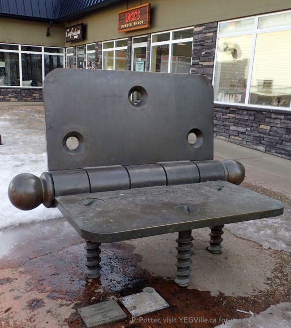
Butt Hinge Art Work in Front of Jack’s Burgers, looking North from Perron St., St. Albert Hx Tour, 2025-03-25, P. Potter. 
Art work, the Buffalo Hunt, looking NE, St. Albert Hx Tour, 2025-03-25, P. Potter. 
Time is a River Art Work, looking South from Perron St., St. Albert Hx Tour, 2025-03-25, P. Potter. 
Blooms Bench Art Work, looking South from St. Thomas toward la Crema Caffe, St. Albert Hx Tour, 2025-03-25, P. Potter. 
Wenden Way (1995), Ken Mackin, looking approximately South from St. Thomas, St. Albert Hx Tour, 2025-03-25, P. Potter. 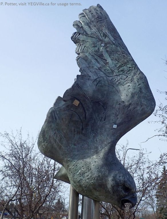
Threshold (1999) art work, Robert Spaith, St. Albert Hx Tour, 2025-03-25, P. Potter. 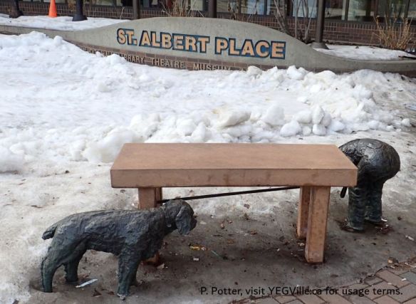
Hide and Seek (1994), Barbara Paterson, in front of St. Albert Place, St. Albert Hx Tour, 2025-03-25, P. Potter. 
Looking West towards the Train Trestle and Big Lake, St. Albert Hx Tour, 2025-03-25, P. Potter. 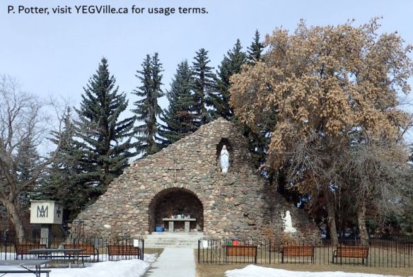
The Grotto behind St. Albert Parish Church, St. Albert Hx Tour, 2025-03-25, P. Potter. 
Interior of the Little While School House, St. Albert Hx Tour, 2025-03-25, P. Potter. 
100+ year old graves in the St. Albert Cemetery, St. Albert Hx Tour, 2025-03-25, P. Potter. 
Butterfly Kaleidoscope (2017), Karen Ho Fat Lee, looking roughly west towards the grain elevators, St. Albert Hx Tour, 2025-03-25, P. Potter. 
Looking West along the CN Rail line towards the Grain Elevators and former station, St. Albert Hx Tour, 2025-03-25, P. Potter.
Notes and Reference
- As this is meant to be an overview, I am not going to dwell on European contact with the peoples they found in the Americas. Nevertheless, insert here perspectives of what happens when a stone aged culture encounters a more advanced one. It is important to remember that while your technology may be stone based, you are still human, and all humans have advanced culture adapted for the environment.
- How, when, and where humans colonized the Americas is a subject that is best left to time travelers or archaeologists (who are a type of time travelers). Humans are an invasive species who use their big brains to exploit whatever environment they stumble across. Some possible theories of how we migrated can be found in this article: https://en.wikipedia.org/wiki/Alternatives_to_the_Clovis_First_theory.
- Cultural Landscapes: Aspen Parkland.
- St. Albert celebrates its roots | St. Albert Gazette.
- St. Albert Roots | Catholic Archdiocese of Edmonton.
- St. Albert, Alberta: Demographics | Wikipedia
- Alberta’s best farmland lost to urban expansion, U of A study finds | CBC
- Adapted from https://en.wikipedia.org/wiki/Sturgeon_River_(Alberta)
- Adapted from https://www.t8nmagazine.com/big-lake/
- Insert here a lot more complexity such as determining where the township exists. This is based on the East-West merdian axis and the North-South latitude axis.
- Residents are raising an eyebrow over new public art | St. Albert Gazette Sep 28, 2018.
- St Albert Botanic Park: Where inspiration is second nature.
- https://www.albertaparks.ca/parks/central/lois-hole-centennial-pp/information-facilities/nature-history/
Further Reading
- The river lot system was more widespread at the time of confederation and was also one of the issues behind the Riel Rebellion. Grout Road in Edmonton, for example, is a beneficiary of the river lot owned by Malcom Grout. Read more: The legacy of river lots evident today | YEG Tracks in Time.
Usage: This site is intended for my personal use only and very select invited guests. My recommendation is for you to stay in bed with the covers pulled firmly over your head.
